Floods of Pakistan

Floods of Pakistan
HELP CENTER

Wednesday, September 22, 2010

THE TWO FLOOD WAVES.........

Pakistan
The two flood waves in Pakistan continue to cause extreme levels of suffering.  According to the FFD hydrographs the water level at Sukkur is now falling slowly after the passage of the first flood wave:


What has been particularly interesting though is that the flood level is not really increasing substantially at Kotri, the large gauging station downstream:

This presumably means one of two things.  First, it could be that the water is finding another route - i.e. that it is bypassing the gauging station.  Alternatively, the water is in effect trapped between the two sites, which might explain the very slow falling limb of the hydrograph. 
The Google Earth satellite image below shows Kotri:
It is possible that the water has flooded the adjacent land, but the news reports indicate that this is not the case, with the suggestion that the bridges downstream of Sukkur are slowing the flow down.  This is dangerous in the context of the second flood wave, which at the moment remains smaller than the first.  This is the hydrograph for Taunsa, which is just below the "Extremely High" flood level:

At Guddu the discharge is still falling, but only very slowly.  Indeed the discharge remains well above the "Exceptionally High" level:

The danger must be that the second flood wave starts to catch up with, and build upon, the stalled first wave.  This would create the potential for an extremely damaging second phase of floods.  It took six days for the first wave to pass from Taunsa to Guddu, and a further day to Sukkur.  The hope must be that the water level starts to fall quickly at these two sites before the second wave arrives.

Unfortunately, it is clear that this slow motion disaster has several more weeks to go, even if there is no further heavy rain.

Tuesday, September 14, 2010

BIO SAND -WATER FILTERATION FOR FLOOD VICTIMS.

WATER FILTRATION FOR UNDER PKR 890/-(US$10)

There are two steps to making water safe to drink. The first step is to filter the water. The second step is to disinfect the water. Charcoal is a valuable ingredient in water filtration.

To make a simple charcoal water filter, select a clean container with a hole in the bottom. Place a single thickness, clean cotton cloth in the bottom of the container and then add a layer of fine gravel (or coarse sand). On top of this, alternate layers of charcoal and sand until the bucket is 2/3 full. Place a larger piece of thin cloth over the top of the container and secure it as a strainer to keep large particles out of your filter when water is poured through it. Illustration courtesy of http://quest.arc.nasa.gov/test/speakersnotes/ITP/912/examples_spsci.html.

Select another wide-mouthed clean container. Fit it with a lid that has a hole matching the one on the bottom of your filter. Set your homemade filter on the lid of your bottom container, which will hold the filtered water. Pour water into the filter and wait for it to drip into the lower container. The resulting water is filtered, but bacteria may still be present. You will need to disinfect your filtered water by boiling, adding chlorine, using the sun, or some other method. If boiling is used, the water should be boiled for ten minutes.

A variation of this method can be utilized for household filtration using a disinfected watertight drum. Washed gravel is placed on the bottom, followed by a layer of fine cloth and alternating layers of clean sand and charcoal topped with another layer of fine cloth. Water is poured through an opening in the lid of the barrel and collected after it passes through all of the layers. An old dinner plate can be placed on top of the sand just below the opening in the lid to stop erosion. An example of such a drum is shown. See this site for more detailed instructions:
http://www.hesperian.info/assets/EHB/06_Chapter6.pdf
Illustration courtesy of http://tilz.tearfund.org/Publications/Footsteps+31-40/Footsteps+34/Letters.htm.

"ACTIONS ARE 
LOUDER THEN WORDS"

This Youtube Video shows that how you can make your own  BIO SAND Filter for a very little investment & turn muddy flood water into drinkable germ free water.
Watch & Learn..................


Monday, September 6, 2010

Pakistan flood disaster imaged by NASA satellite


By James Dacey

The flooding in Pakistan triggered by heavy monsoon rains at the end of July has killed more than 1200 people and affected more than 15 million others across the country, according to government estimates. The country’s president, Asif Ali Zardari, said yesterday that it will take up to three years to recover from the natural disaster, as quoted by the Associated Press.

This pair of images shows the extent of the floodwaters within the central and southern parts of Pakistan, where the image on the left is from 8 August 2009 and the one on the right is from 11 August 2010. They have been captured by the Nadir (vertical viewing) camera on the Multi-angle Imaging SpectroRadiometer (MISR) instrument aboard NASA’s Terra spacecraft, which was launched in 1999.

The Indus River can be seen meandering across the image from upper right to lower left. But in the later view, flooding can be seen clearly in much of the surrounding region, particularly in the Larkana District to the west of the river. Each image is 300 × 425 km and false colours have been employed to enhance the contrast: water appearing in shades of blue and cyan; vegetation as red; clouds as white; and sediment as tan.

Since this image was captured, the floodwaters have spread further south into the Sindh province, which lies in the bottom half of this image. The United Nations warned yesterday of thousands more imminent evacuations, along with the threat of waterborne diseases, food shortages and lack of shelter.


Story Source:http://physicsworld.com/blog/2010/08/pakistan_flood_disaster_imaged.html

Pakistan floods bring out TED Fellows community


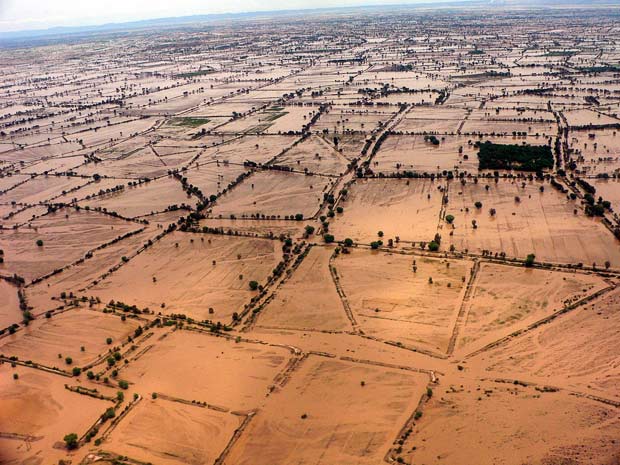
Upwards of 20 million people are suffering from the massive flooding in Pakistan, according to the United Nations — more than the number affected by the 2004 Indian Ocean tsunami, the 2005 Kashmir earthquake, and the 2010 Haiti earthquake combined. Following record-breaking monsoon rains, at least 1,600 people have been killed, an estimated 72,400 homes have been destroyed, and crops from some 1.6 million acres of land have been ruined.

The international community’s tepid response to Pakistan’s worst natural disaster in history has not quelled efforts by Pakistani citizens — including several TED Fellows — to help people affected by the flooding. Faisal Chohan has built pakreport.org as a platform for reporting and mapping incidents, directing relief to areas that need it most. Other Fellows are also using their specific expertise to provide support to suffering people.

With over 20 million people affected by the floods, Faisal’s pakreport.org is expected to be the biggest usage yet of the crowdsourcing tool Ushahidi. The platform collects eyewitness accounts of flood-related incidents via SMS, email and the web. It then verifies them for accuracy and plots the data points on a map, providing up-to-date information to aid workers — an invaluable service when conventional media outlets and communication lines are down.

To contribute to accurate mapping of the crisis, people can text their eyewitness accounts of the flood to 3441 with the location of the incident. The message should begin “FL,” followed by a space and then the observation.

Sharmeen Obaid-Chinoy, currently in Karachi away from the flood waters, has been working to register the influx of Internally Displaced People (IDPs) in her hometown. “It’s easy to come and melt away in the largest city in the country,” she says. So she and other volunteers are working to account for the IDPs to ensure relief can be directed to them. In addition, Sharmeen stays connected with other journalists in the field via Twitter and texts, and connects them with her international network to provide medical support and other aid.

Because international relief agencies tend to concentrate on the highly populated metropolitan areas, Awab Alvi and Asher Hasan are traveling to the more neglected flood-affected areas in remote parts of the country. After delivering three truckloads of food and tents to some 550 people in the Sukkur and Shikarpur districts, Awab hopes to obtain more rations and tents to create a temporary “tent city” for people sweltering in 100-degree weather.

Asher and his organization Naya Jeevan, which provides micro insurance to the very poor, has partnered with Google’s Crisis Management Team to map locations of medical facilities in the region. Asher and his team are heading into the Charsadda district to provide immediate medical relief and to analyze the long-term medical needs of the region, intending to provide health care coverage for 25,000 flood-effected people in the next year.

From outside the country, Sanjana Hattotuwa contributes his expertise by curating a Pakistan flood crisis wiki providing a comprehensive collection of information and links to important news and aggregation portals.

Many other people outside of the region, including Juliana Rotich and Erik Hersman, founders of Ushahidi, have been volunteering remotely for pakreport.org and other organizations. Readers who want to help pakreport.org with donations of time (translating, tagging, verifying reports, spreading the word) or money should click the “Support Pakreport” button on pakreport.org. To contribute an organization Sharmeen works with, visit Indus Rehabilitation Trust. The information on Awab’s efforts can be found at OffroadPakistan, and Asher is working with ShineHumanity.org and UMTrust.


for full story & reference sites , click the link below:

http://blog.ted.com/2010/08/19/pakistan-floods-bring-out-ted-fellows-community/